Resarch framework

WHAT WE INVESTIGATE

Core Themes

Transport Moored Arrays

A transport moored array is a scientific system of instruments anchored to the seafloor to continuously measure the transport of heat, salt, and other constituents dissolved in seawater. Transport moored arrays are crucial tools in oceanography for understanding global ocean circulation and its role in climate. The arrays are strategically placed in regions where the main current covers as small an area as possible, such as at the boundaries of the ocean or in straits and passages.

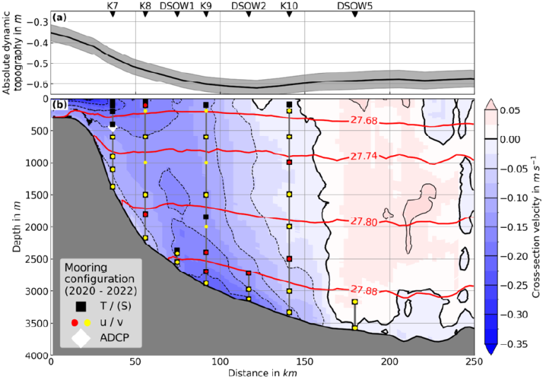
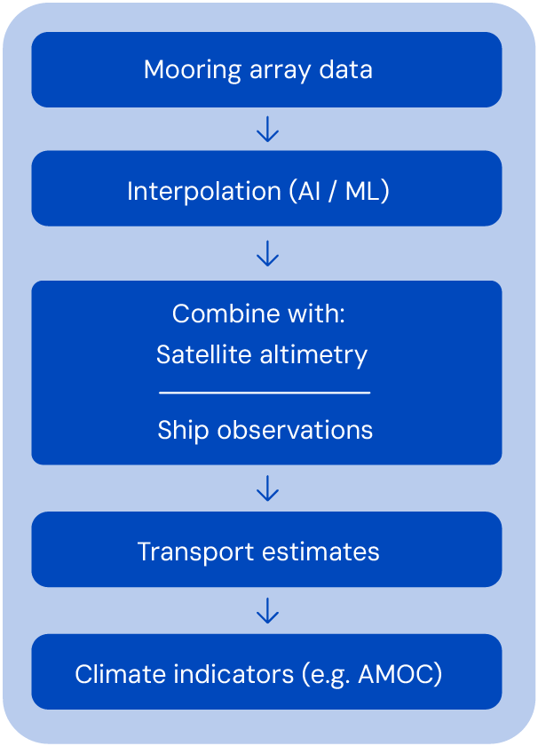
The design of a transport moored array ideally considers the typical structure of the flow by installing instrumentation in a way that samples across all flow features such as local minima/maxima of the flow. Estimating volume and property transport from the array of instruments requires the application of interpolation techniques (including AI/ML techniques) and is most successful when also considering further observational data across the array, such as ocean surface altimetry and high resolution ship section data.

In key areas, a combination of transport moored arrays allow to derive large scale climate indices such as the strength of the Atlantic Meridional Overturning Circulation (AMOC) – for example through the Overturning of the Subpolar North Atlantic Program (OSNAP)

Example for a transport moored array for the 53°N Observatory at the exit of the Labrador Sea (Subpolar North Atlantic): (a) the mean satellite based dynamic topography across the array with locations of the locations of the 7 moorings that form the Transport moored array is shown in the upper graph. In the lower panel (b) the mean velocity structure as observed from high resolution ship surveys is shown (flow out of the page in blue, into the page in red) and the instrumentation on the moorings (vertical lines) are shown with symbols for the sensors installed from 2020 to 2022: T/(S) indicate temperature (and salinity) sensors, U/V stands for velocity sensors and ADCP for a velocity profiler.

Global Ocean Watch

Inspired by the Global Atmosphere Watch (GAW) program of the World Meteorological Organization (WMO), the OceanSITES Global Ocean Watch initiative is a global network of time-series stations designed to monitor the physical and biogeochemical properties of the oceans. These stations measure variables such as temperature, salinity, oxygen, plankton, carbon dioxide, and pH, providing essential data to understand climate change, ocean variability, and ecosystem dynamics, as well as to inform science-based policy on issues like oceanic CO2 uptake.

Each Global Ocean Watch mooring (including installed sensors and instrument depths) is designed according to the vertical biological structure of the ocean depending on light penetration, covering the epipelagic (photic) layer (<200m), mesopelagic (<1000m), bathypelagic (1000-4000m), and benthic layers over the seafloor. This configuration enables the study of key processes including net community production, carbon export between layers, and variability in dissolved oxygen and pH, as well as benthic ecosystem assessments using seabed cameras. Observations are complemented by high-resolution ship-based surveys, where water samples for additional estimates are obtained.

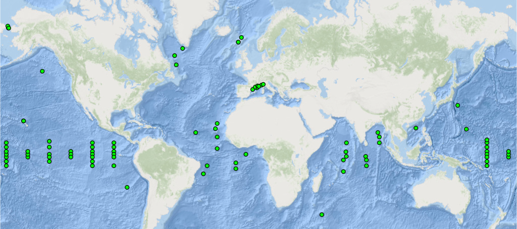
OceanSITES Global Ocean Watch stations are located in representative oceanic regions, capturing variability across large-scale biogeochemical provinces and gyres.

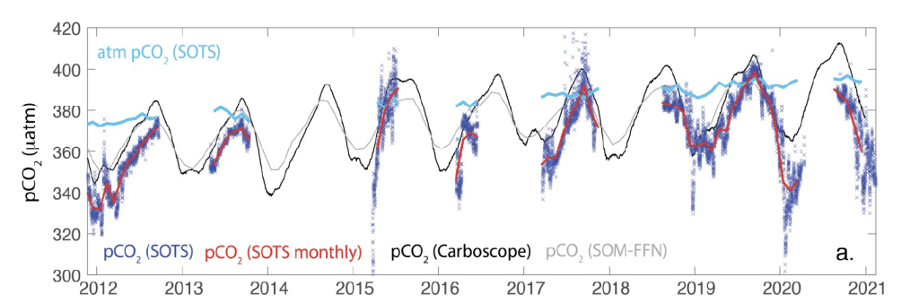
Time series of surface water (dark blue x’s) and atmospheric (blue line) pCO2 observations at the SOTS site between
2011 to 2021

Deep Ocean Observing

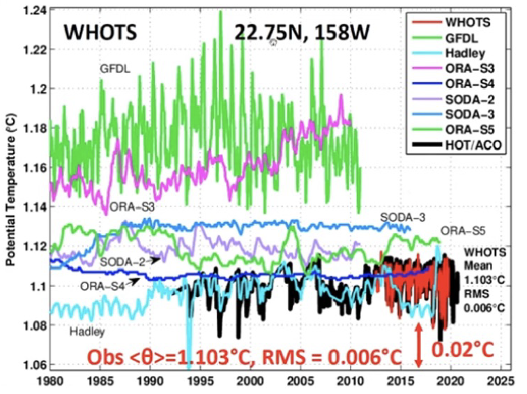
Despite the deep ocean being the largest heat and carbon reservoir on Earth, there is a critical lack of data and knowledge. Expanding deep-ocean observations is essential to understand its current state, response to climate change, and impact of human activities. OceanSITES contributes by installing temperature and salinity sensors deeper than 2,000 m in the water column and near the seafloor at depths over 5,000 m on some moorings.

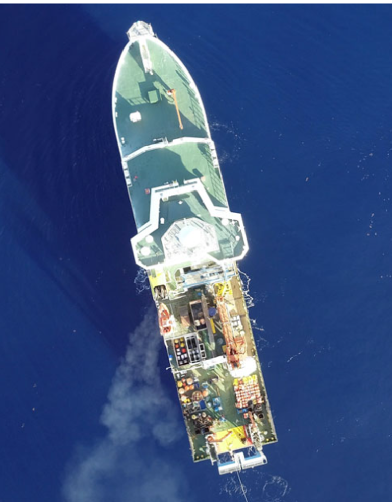
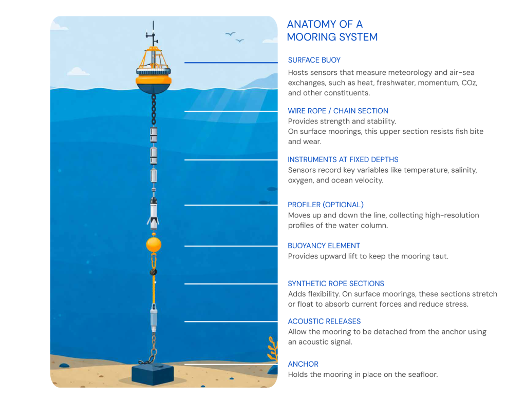
The primary method to collect these time series is through moorings anchored to the seafloor. Subsurface moorings, made of wire rope with a buoyancy element, can remain in place for months to years, carrying battery-powered instruments at fixed depths. These moorings host instruments measuring temperature, salinity, currents, and oxygen, with pressure sensors tracking depth from on and near the top buoyancy element down to near the sea floor, above the anchor.

Surface moorings feature a buoy to monitor surface meteorology and air-sea exchanges of heat, freshwater, momentum, and CO2. Some also carry deep temperature and salinity record-ers near the seafloor.

Deep temperature recorded at WHOTS (Woods Hole- Hawaii Ocean Time-Series, red and black line) (aprox. 4700 m) compared with different reanalysis and models.

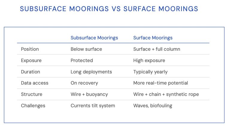
SUBSURFACE MOORINGS VS SURFACE MOORINGS

--

Subsurface Moorings

Surface Moorings

Position

Below surface

Surface + full column

Exposure

Protected

High exposure

Duration

Long deployments

Typically yearly

Data access

On recovery

More real-time potential

Structure

Wire + buoyancy

Wire + chain + synthetic rope

Challenges

Currents tilt system

Waves, biofouling

Air / Sea Interface

WHAT WE MEASURE

Essential Ocean Variables

Learn about the concept of “Essential Ocean Variables” (EOVs); learn which EOVs can be derived from the data that is collected at the OceanSITES sites.

Essential Ocean Variables (EOVs) are key to track the ocean’s state, support forecasts, and reveal climate change impacts. Approved by expert panels of GOOS and GCOS, EOVs are derived from observational data and respective measures for its heterogenity (e.g., uncertainty for physics). Via EOVs reliable and trusted ocean indicators are derived.

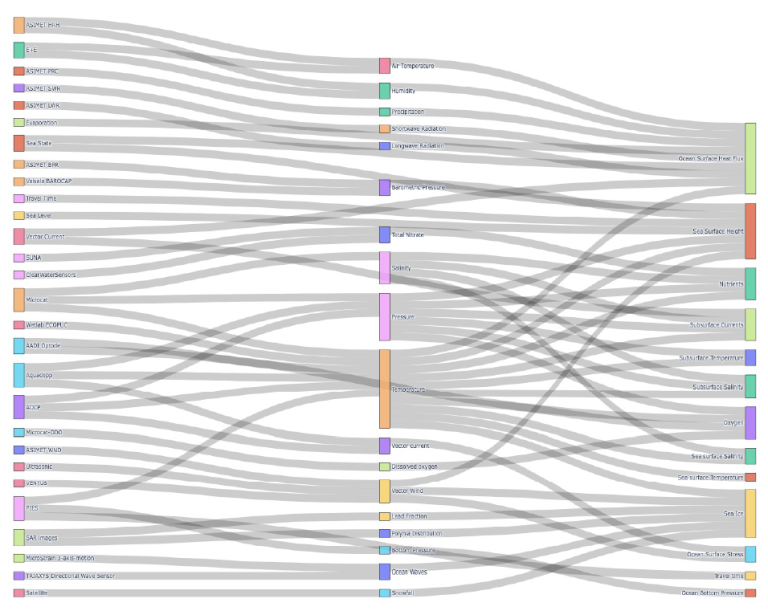
OceanSITES delivers a wide range of observations, enabling the derivation of physical, biogeochemical, and biological EOVs, as well as Essential Atmospheric Variables (EAVs). The relationships between instruments, measured parameters, and derived EOVs can be visualized in a Sankey Diagram below.

WHAT WE MEASURE

Sites

The network OceanSITES comprises nations observatories run by PIs around the global.
The observatories are at fixed locations called “sites”.

SITES KEY CHARACTERISTICS

MANDATORY

DESIRABLE

It is operated at a fixed location

It is designed to be long-term (typically greater than 5 years)

Metadata about the site and the operations is provided to the GOOS & GCOS metadata portal OceanOPS

Collects multidisciplinary data

Data is made openly available and information about the access it provided to OceanSITES

Accesing
Data

Scroll to Top